
Source: http://www.universetoday.com/2009/02/02/google-oceans-google-mars/
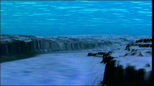
Google Earth now allows you to probe the depths of Earth's oceans as well as fly through the giant canyons or volcanoes on Mars. Google Earth 5.0 was unveiled today, with substantial upgrades for both the Earth and the Red Planet. Google worked in conjunction with NOAA and NASA to incorporate data from our undersea explorations and the spacecraft orbiting Mars. For the first time, you'll be able to look at the two-thirds of our planet covered by the oceans, take a tour below sea level, and even look at historical imagery to see things like coastal erosion. On Mars there's a rich conglomeration of images, including the most recent from the Mars Reconnaissance Orbiter to provide an immersive 3D view of Mars.
Marine scientists say the electronic images will boost awareness and increase public support for marine conservation, while NASA says the new features in Google Mars will aid public understanding of Mars science, while also providing researchers a platform for sharing data similar to what Google Earth provides for Earth scientists.
In Google Oceans, you can click a function called Touring and you can create narrated, illustrated tours, on land or above and below the sea surface, describing and showing things like a hike or scuba excursion, or even a research cruise on a deep-diving submarine.
By choosing among 20 buttons holding archives of information, called “layers” by Google, a visitor can read logs of oceanographic expeditions, see old film clips from the heyday of Jacques-Yves Cousteau and check daily Navy maps of sea temperatures.
While only 5% of the ocean floor is mapped in detail, the replicated seas have detailed topography reflecting what is known about the abyss and continental shelves with rougher areas where little is known.
Download Google Earth 5.0.
Google Earth now allows you to probe the depths of Earth's oceans as well as fly through the giant canyons or volcanoes on Mars. Google Earth 5.0 was unveiled today, with substantial upgrades for both the Earth and the Red Planet. Google worked in conjunction with NOAA and NASA to incorporate data from our undersea explorations and the spacecraft orbiting Mars. For the first time, you'll be able to look at the two-thirds of our planet covered by the oceans, take a tour below sea level, and even look at historical imagery to see things like coastal erosion. On Mars there's a rich conglomeration of images, including the most recent from the Mars Reconnaissance Orbiter to provide an immersive 3D view of Mars.
In Google Oceans, you can click a function called Touring and you can create narrated, illustrated tours, on land or above and below the sea surface, describing and showing things like a hike or scuba excursion, or even a research cruise on a deep-diving submarine.
By choosing among 20 buttons holding archives of information, called “layers” by Google, a visitor can read logs of oceanographic expeditions, see old film clips from the heyday of Jacques-Yves Cousteau and check daily Navy maps of sea temperatures.
While only 5% of the ocean floor is mapped in detail, the replicated seas have detailed topography reflecting what is known about the abyss and continental shelves with rougher areas where little is known.
Download Google Earth 5.0.
Last edited:
